Saturday 30 March 2024

From Rodney's Bay to de Guichen's Martinique and "All the way to America"

Pigeon Island, Rodney Bay

We left Rodney Bay bound for Le Marin, Martinique at 1045 on 27th March 2024. Bonny's short passage to Le Marin was an uneventful one under power due to the almost complete lack of wind. 

The crowded Anchorage at Le Marin

On arrival we dropped anchor in the extremely crowded anchorage and were reaquainted with friends from our stay in Tobago. Plans were soon being made to form a small, multi-national, expeditionary force of friendly vessels comprising: SV Vitruve πŸ‡«πŸ‡·, SV Lea πŸ‡©πŸ‡ͺ, SV Aura πŸ‡ΈπŸ‡ͺ and SV Bonny πŸ‡¬πŸ‡§, to recignoitre Martinique's south east coast and secure a suitable location to celebrate.... well, whatever we wanted!

Back in 1780 however, it was a very different story. On 17 April, the fleet of the newly appointed French Commander in the Carribbean, Comte de Guichen, acting in support of the fledgling USA, departed Port Royale (now Fort de France), Martinique, intent on creating great mischief amongst the enemy, by capturing various British territories in the Carribbean.

However, Rodney's lookouts at the signal station on Pigeon island, St Lucia, quickly spotted the dasterdly deeds afoot - or even awash - and communicated their observations by flags and semaphore to their Admiral and his fleet of men-o-war anchored in his Bay below.

Sensing a great career enhancing opportunity, Rodney ordered the fleet to weigh anchor and pursue the French expedition. The ensuing gathering was far from friendly. 

Within a few hours and having gained the great tactical advantage of being to windward of the French ships, Rodney signaled a cunning battle plan to his commanders, which if implemented successfully, would all but ensure victory over his adroit foe, Comte de Guichen. Such a great victory would guarantee his further advancement up the ranks of the naval command structure.

View of the battle by Thomas Luny

Unfortunately, it appears that the Commander of Rodney's lead ship, HMS Stirling Castle, one, Robert Carkett, misunderstood Rodney's instructions and as a consequence, things did not go quite to plan. Rodney's anticipated victory turned into a lenghty action ending in a stalemate which allowed the French to withdraw. The French lived to fight another day and subsequently, one of de Guichen's Admirals, Compte Grasse, inflicted the humiliation on Rodney, of capturing and holding Tobago despite the presence of Rodney's fleet. Rodney subsequently received a roasting in the British tabloids of the time, for failing to eject the French forces.

Ultimately however, Rodney was to have the last laugh, with his victory over the French in "The Battle of the Saints" (a group of small islands to the south of Guadalupe) in 1782. However, even this significant victory was not enough to ensure the retention of Britain's greatest overseas colony. Britain's wider struggle with her rebellious American states was not going well. The 1783 Treaty of Paris followed the Battle of the Saints just over a year later and the United States of America was formally constituted as an independent nation.

Our activities were much more convivial. After a gorgeous sail around the South East of Martinique, we navigated a slightly tricky pass through reefs and all four boats anchored safely nearby the "Bais des Anglais".

Damian cooked a Baracuda to feed us all that he caught en route and we all headed over to Lea with our own offerings of food and drink for a most enjoyable evening of food, booze and most importantly, delightful company.


Wednesday 27 March 2024

To Rodney Bay


We dropped our mooring at the base of the Petit Piton under sail at around 0900 on 24th March and departed Soufriere for Rodney Bay at the extreme north ofthe Island.

Rodney Bay is named after the 18th Century Admiral Rodney who led a slightly chequered career with the Royal Navy. He is credited with creating the naval base on Pigeon Island on the north side of the bay which now bears his name but as mentioned in a previous post, he was heavilly criticised for allowing the French to capture the island of Tobago in 1763 without a shot being fired in its defence.

Before visiting Pigeon Island to survey Admiral Rodney's good works, Mick and I had a most important mission of our own to undertake in the Capital of the Island, Castrise, some five miles or so down the coast. Our mission was to collect a replacement Ocean Crusing Club House flag which m
Mick had ordered and paid for and had arranged to be sent to the Post Office. So we got up early on Monday and took the dinghy into the Lagoon in order to catch the bus into Castrise. 

Our first obstacle was a local on the make at the dinghy dock. Initially all smiles, he took our painter and bag of rubbish, but then before we could proffer our thanks by way of a $5 EC note, demanded payment of $10 US  for his troubles - the equivalent of $27 EC! He produced a $10 US note as evidence that this was what others had given him. We said "no" whereupon he grudgingly suggested $10 EC woud do. We said no again and I took the bag of rubbish intending to dispose of it myself. At this point he even more grudgingly accepted the $5US thank you we had first offered. Off we went only for me to quickly imagine a return in which I found a vandalised dinghy. Consoling myself with the thought that that would not be a good advertisement of his services to subsequent customers we continued on our way.

So off we went and caught the bus into Castrise. A lively and substantial town comprising a mixture of old style Carribean properties built from wood and much more recent stone and concrete edifies such as one would find in any western town. We found the Post Office easilly enough only to discover a notice on the door announcing that it was closed all day for the pupose of deep cleaning.

We decided to waste no more time and instead went in search of the bus back to Rodney Bay with the intention of visiting Pigeon Island - which originally, we had planned to do the following day, when,  now, we would have to return to Castrise.

After lunch in the Marina we set off on foot along the shore for Pigeon Island...

.... a walk of about two miles. It involved walking across the beach fronts of two holiday resorts. 

The resorts were not allowed to own the beaches and so we were free to walk across them. The first resort had breached the beach and built a canal to access a lagoon behind it and they therefore had to provide a free ferry service across the canal to anyone who wanted to cross. The boatman was a friendly soul and so we tipped him with $5 EC which he seemed happy with. 

The second resort had the most hilarious approach to visitors yet. We arrived on their section of the beach to be 'greeted' by a most splendid looking footpath of stones set into the sand that traversed 'their' section of the beach. Along it we walked only to be hailed from behind by a security guard. We stopped and waited. I suspected I knew what was about to follow. Rather sheepishly he informed us that we were not allowed to walk on the footpath but would have to walk on the beach itself. I feigned surprise - "do you think visitors are going to wear out the path faster than the guests", I asked tongue in cheek. The poor chap was clearly most embarrased at having to enforce such a crazy rule and said he was sorry but that was the rule. I toyed with the idea of walking on but clearly it woud be him who would get it in the neck if the boss - whoever he or she was - saw what was going on and so I smiled - said I understood it wasn't his fault and we moved off the path onto the beach to continue our quest to discover Admiral Rodney's legacy.

It cost $10 US each to enter the Pigeon Island Park which, once we had been around the entire park and had seen what there was to see - not a great deal - seemed over priced. Hopefully at least some of the ordinary local folk benefit from it.

The first structure of note was Fort Rodney perched at the top of the southern peak of Pigeon island. 


Stone ramparts, two old naval cannons minus their carriages and the old magazine store was all there was to see along with an explanatory notice board.

Steps into the Magazine 

The view from Fort Rodney was impressive - nothing was likely to escape the attention of the cannons up here...
Rodney Bay, where the British fleet was stationed, was well protected.

Next was "Musket Redoubt" - a sort of hidy hole on top of the hill from which defenders could hide away and be ready to poor down the slopes on either side to rout any French attackers silly enough to attempt an uphill assualt. 

Next we crossed to the other end of Pigeon Island and up the even higher, Flagstaff Hill, from where the troops would signal the fleet below in Rodney Bay, should they observe any sign of a French intrusion from Martinique some 25 miles to the north and which we could make out through the haze. 

Nearby was the "Two Gun Battery" overlooking the bay to the North of Pigeon Island. Presumbly the concern was that a wiley Frenchman or two may escape detection by the Flagstaff lookouts and gain access to the bay. If so they would be sitting ducks and no doubt sent to the bottom without further ceremony!

Only one of the two guns remained but at least it still had its carriage...

The elevation scale was still readable.

Making our way down the hill towards the entrance/exit we then came across the old barracks which were in sorry state. 

It looked as if perhaps some attempts at preservtion had been started many years ago but had stopped after very little progress had been made. The place was surrounded by warning signs that the structure was unstable - the signs looked to be nearly as old as the crumbling buildings themselves.

On our way back to the marina we stopped off very briefly at a beach cafe only to beat a hasty retreat once we discoverd they were charging double what we had earlier paid for a beer in the park restaurant. Later we stopped off at a roadside bar that charged normal prices and was run by  most charming woman who gave us the low down on the local political scene. Apparently there re two main political parties in St Lucia. The Labour Party and the United Workers Party. We couldn't work out which was more left wing and which more right wing, but perhaps like other countries one could mention, there wasn't much difference!

Today - Tuesday 26th March, Mick returned to Castries to collect our flag, only to be foiled once again. The Post Office denied all knowledge of its existence. We were pretty pissed off because it was the only reason we had stayed. Yesterday we would have had a good sail to our next destination, Martinique, whereas tomorrow it looks like there will be no wind and we will have to motor. We're leaving, because there are unusually, westerly winds on the way, which will make this anchorage rather uncomfortable uncomfortable!


Tuesday 26 March 2024

Out and about around Soufriere, Saint Lucia

View from Soufriere over the bay.

On arrival at Soufriere we were directed to a mooring by one of the local 'boat boys' but after mooring up we realised we were on a private mooring that put us far to close to another boat and to the town shore (and therefore a rather easy target for any would be wrong doers). The owner was a rather surly chap too. We therefore moved to an official mooring much further away from the town near the foot of the Petit Piton. The long dinghy haul into town was more than compensated by our now beautiful and clean surroundings...

The following morning I took the dinghy in to town to check in with the Customs and Immigration authorities and took a look around and picked up a few provisions...

In the afternoon we joined our friends Johannes and Olena whom we had met back in Charlotteville for a walk up to one of the islands waterfalls...

We weren't expecting the water to be hot, but it was heated by the thermal activity of the nearby volcano!


Later that evening we were invited for dinner by Johannes and Olena on board their boat Lea and had a most enjoyable time.

The next morning we teamed up with them again for a short guided tour by car around some of the local tourist spots: the (now non-active) volcano (where stupidly I left my phone in the car), a view point and the botanical gardens containing beautiful tropical plants and hummingbirds. Unfortunately the latter are so small and fast that capturing them with my phone camera proved impossible.

Soufriere from the view point with Petit Piton (nearer the camera) and Grand Piton in the background.

Whilst I was unable to photograph any humming birds I had more success with these....
The morning ended on a slightly sour note when our guide took exception to our request to vary our itinerary a little.  His attitude felt all too typical of the outlook of many locals in this very tourist centric town and compared poorly with that of the lovely people we had met in Tobago.

Later however, we had lunch in a local restaurant on the outskirts of town away from the tourist hawks, where in addition to a basic but excellent value meal, could not have been treated better.

In the early evening Johannes and Olena joined us on board Bonny for 'sundowners' with the Petit Piton providing a stunning backdrop to a gorgeous sunset.

The following afternoon we all piled into Bonny's dinghy and went snorkeling around the base of the Petit Piton just a few hundred metres from where we were moored. This was probably the best snorkeling I'd experienced yet, with lots of different fish and coral species in evidence. The highlight for me was spotting a very large green fat fish with large eyes some 5 metres or so below me on the rocky bottom. 'He' was clearly keeping just as close an eye on me as I was on him! I was rather glad not to be too close.

Somewhat surprisingly after about 30 minutes, I began to feel cold  and so was the first to return to the dinghy. Bad timing on my part because no sooner was I out of the water than clouds gathered and the wind got up and in no time I was shivering violently - in the tropics - very odd. I warmed up once the cloud and wind passed however.

More sundowners on Bonny were followed by one of Mick's culinary delights - pasta carbonara - yum, yum. Fresh pineapple for dessert too!

The following morning Lea departed for Rodney Bay at the northern end of the island. Mick and I spent the day securing our previously wonky engine (see Wonky Engine Worries).

Wonky Engine Worries

I completely forgot to report this development in my last post..

On departing Charlotteville, Mick noticed a new squeaky like noise eminating from the engine compartment. On investigation we noticed the engine was wobbling around rather alarmingly on its mountings. We were not under power, but sailing with the engine in neutral and the propeller shaft turning as per the instructions in the Gearbox manual. This always creates an audible noise, but it is possible that the noise levels had increased without us noticing until Mick detected the new noise. 

I've never had cause to study the behaviour of the engine when sailing before and so wasn't certain whether what we were observing was normal or not. To be on the safe side we decided it would be best to put the engine into reverse as this was not explicitly prohibited by the gearbox manual. 

Finally, the day before we were due to leave Soufriere, we inspected the engine mountings and found that two of the four - front and back, diagonly opposite eachother - had worked lose. 

Forward port mount 

Aft starboard mount

The locking nuts on both are under the red 'feet' and clamp the engine/gearbox up against the top nylock nut so it's aligned with the propeller shaft.

The top nuts of both of them appeared to have unwound on the engine bolts' threads. Fortunately however, Mick spotted that they were nylock nuts and therefore were very unlikely to have moved. What had actually happened was that the nuts underneath the engine feet had worked lose and had dropped down the engine bolts! 

Both of the bolts and their nuts were quite difficult to access, with very restricted space in which to engage a spanner. It was therefore a slow laborious process to tighten the nuts. 

Once finished, I then noticed that all four of the bolts connecting the gearbox's flexible coupling to the prop shaft were also lose and so those too had to be tightened up. 

The flexible coupling is the yellow plastic disc visible behind the gearbox.

All in all, the job took most of the day but it was a big relief to have discovered the problem and to have resolved it before any damage was done. As far as we could tell anyway! 🀞🀞🀞

On our subsequent passage up the coast to Rodney Bay the engine was far more stable and the noise of the propeller shaft turning was significantly diminished. 

Sunday 24 March 2024

Goodbye Tobago - Hello Saint Lucia. What's the difference between a GPS and a bit of string? An answer from the archives.

Bonny - left of centre - in Pirates Bay, Tobago

We finally dragged ourselves away from our mooring in Pirates Bay, the local town of Charlotteville and the island of Tobago at 1040 on the 19th March and set sail for Saint Lucia.

We really enjoyed our time on Tobago - a beautiful, quiet island where tourism is a relatively small component of the local economy and as a consequence, neither the island or its people are overly affected by it. Not a high rise hotel in sight and no hassle, just polite enquiries from vendors who return a polite "no thank you" with an equally polite and always cheerful "enjoy your day" or similar. 

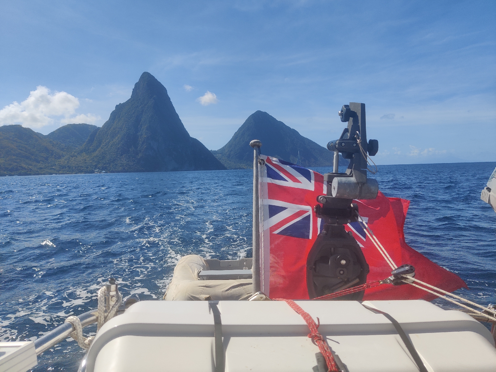
A cracking sail of around 26 hours to cover the 155 miles to Soufriere on the south west coast of Saint Lucia followed. We had a fresh breeze from the East which, with the wind just forward of the beam, put us a close reach, a fairly comfortable point of sailing. The forecast of 15-20 knots of wind pursuaded me that a single reef in the mainsail and a full Genoa should provide about the right amount of sail area and whilst there were times when more sail would have provided a little more speed - our eventual average of just under 6 knots was about the most we could expect without making frequent sail changes in response to varying wind speed.

We adopted a 3 hours on, 3 hours off watch system and for the first time I took the first watch from 2100 after MIck had served up another excellent dinner - this one was single pot dish of rice and mineced beef.

By midnight I was pretty tired but as usual found it very difficult to sleep on the first (and in this case the only) night of the passage. Back on watch at 0300 I found a largely clear night with a young moon now low in the sky. For the first time I can remember since leaving Europe, Scorpio was clearly established in the southern sky behind us and with the boat surging along at near top speed it was a most enjoyable three hours. Occasionally a slight course correction was required, either in response to a slight change in wind direction or a variation in the ocean current. 

We picked up a mooring at Soufriere some 26 hours later....

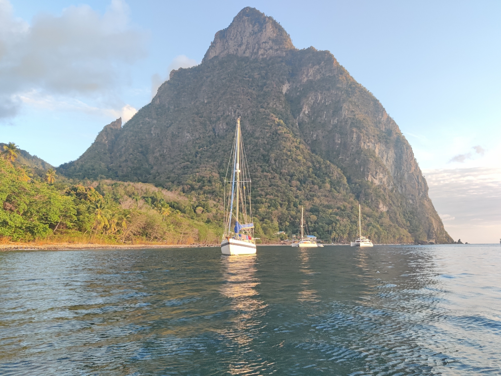
Bonny on a mooring under the Petit Piton near Soufriere.

Bonny's Raspberry Pi computer, coupled with a GPS receiver and the free Chartplotter software, OpenCPN, makes monitoring our progress and position so much easier than in pre-GPS days. I simply have to plot a desired course on the screen and then monitor the boat's position relative to that course. If we wander off the desired track one way or another, I make a small adjustment to the angle of the wind vane relative to the wind to bring us back on track.

Above, the thin blue line is the plotted course and the thick yellow line our actual track.

Without such luxuries, I might be able to confirm our position once or twice during a 24 hour passage with a sextant, if that is I had revised my plotting and sighting techniques sufficiently, but more likely, would be dependent on "dead reckoning" to estimate our position. 

It's a time consuming process that few yachtspeople resort to these days. One needs to plot the boat's heading; the boat's speed through the water/distance travelled through the water over a given period); the amount the boat's track deviates from its heading due to leeway (sideways drift) and the direction and speed of the body of water the boat is sailing through. 

Boat speed through the water can be measured reasonably accurately by a device called a log. Bonny came equipped with two ancient ones. Here's one....


And here's the other which as you can see I subsequently got going on our passage up the coast from Soufriere to Rodney Bay..

The end of the line with the propeller attached to it, is trailed behind the boat. The other end is attached to a shaft in the display unit. The shaft turns a dial via a series of gear wheels to indicate the boat's speed and another (on the first one above only) to show distance travelled. In the second one a more conventional tripometer is operated (through the water in both cases). Modern versions of the same thing, dispense with the need to trail a propeller on a piece of string, by, instead, inserting a propeller on a shaft  into the water through a tube in the boat's hull. That's then connected to an eletronic display unit via a special electronic cable. 

Today, nearly every boat has a GPS unit that displays its position and measures its speed over the ground in the same way as a car's satnav. That's enough to enable accurate navigation, but without a speed log it does mean you can't compare the boat's speed through the water with its speed over the ground and thereby establish the speed of any current that might exist.

A competent skipper get's to know how much leeway their boat makes, but without a GPS, the effect that ocean currents have on the boat's position can only be estimated until a fix is obtained.

To find one's estimated position without GPS, all the above variables have to be plotted on a paper chart. Only when 3 land marks or other navigational aids have been identified and bearings taken of them and plotted on the chart, can the boat's position be accurately determined, or 'fixed'.

Practice rarely makes perfect, but the few experienced sailors, who continue to practice these techniques, can make a pretty good fist of plotting a DR position over 24 or even 48 hours. After that though, even small errors mount up until the navigator has only a very general sense of where their vessel is.

Back in the 1970's, when traversing the English Channel on my Dad's old converted Lifeboat, 'Chlamys', rigged as a standing gaff cutter and endowed with an 'occasional' engine, dead reckoning was the only way to track our position. 

It's worth bearing in mind that during the course of a typical 80 mile crossing from the south coast of England to the Cherbourg Penninsula or Alderney, one usually only had to endure a few hours of uncertainty between losing sight of landmarks or navigational lights on the English coast and picking up the French ones. Compare that with our 155 mile passage from Pirates' Bay Tobago to Soufriere, Saint Lucia.  It's twice the distance and there are no navigational lights or other aids. Without a GPS, a navigator would be unable to fix his position for many hours and would only have the vague shapes of distant islands during the day, or the far away looms of town lights to guide them at night through the constantly changing ocean currents (as opposed to the highly predictable tidal streams of the English Channel). Take all that into account and you get a sense of how much more demanding, old school navigation would be out here, compared with home waters, or when compared with modern GPS/Chart Plotter navigation.

Back in the 1970s, even when 'just' crossing the English Channel, a good landfall was worthy of celebation. If the navigator's fix approximated closely with their EP, the rest of the crew breathed a collective sigh of relief and showered their hero with congratulatory pats on the back whilst making extravagant promises of buying beer in the pub later in the evening!

On bad days it was a different story. Here's what happened to us one fateful day back in 1974 or thereabouts, when undertaking the 80 mile crossing from Portsmouth to ...... well you'll have to read on to discover, to where.

First a bit of background.

In the 1970's, Chlamys' navigational equipment consisted of a compass and a chip log (a triangular piece of wood tied to the end of a piece of string of known length), a copy of the REEDS Nautical Almanac and a leadline (a long piece of string with a lead weight on the end for measuring the depth of water. No electronics. No internet (it hadn't even been imagined). No VHF radio, but we did have a long wave receiver for listening to the shipping forecasts

Chlamys' speed through the water was estimated by timing how long it took her to travel the length of the piece of string attached to the 'chip'.

Her heading (the direction in which her bow pointed), was worked out by subtracting or adding the magnetic variation (from True north) listed in REEDS from the heading shown on her compass - which by the way, would constantly vary around 20-30° from the prescribed course, as the helmsman made adjustments for changes in wind speed and direction.

In theory we should also have taken compass DEVIATION into account. That's the amount by which Chlamys' compass heading, deviated from the actual magnetic heading. Magnetic deviation varies by heading and is boat specific. It should be recorded in the form of a deviation chart which typically shows an 'S' shaped curve oriented over a north/south axis. In practice we never bothered because no one could steer Chlamys sufficiently accurately for the few degrees of deviation to have any practicable effect.

We estimated Leeway by looking at the boat's wake and judging the angle between it and the boat's heading. That, combined with the boat's heading, gave us the boat's direction of travel through the WATER.

Finally, the boat's direction of travel over the GROUND (COG) was estimated by adding the effects of the tidal currents - listed in REEDS and shown on the paper charts - to her track through the water.

So, with an estimate of our boat's speed and of her direction of travel - her 'COG', our navigator estimated Chlamys' position and plotted it on a paper chart every hour. 

To return to the events of the day in question...

Having delayed our departure for 6 hours due to fog, we eventually left Portsmouth Harbour around midday with a forecast of fog PATCHES and little wind. The distinction between this and the previously forecasted fog BANKS, was enough to persuade an impatient skipper that the crossing was viable. So we left, confident in the knowledge that the fog PATCH that enveloped us and reduced our visibility to a couple of hundred yards (we could just make out the eastern and western extremities of the harbour entrance through the murk as we left) would soon lift. 

After 6 hours of motoring the fog patch showed an uncanny ability to follow us. After 12 hours it had clearly developed a malign intent to frustrate our navigator and harrass the skipper. After 18 hours it had assumed supernatural powers of adhesion to the good ship Chlamys.

"We should be approaching the beach off Cherbourg" announced the navigator. Over went the leadline to check the depth. No bottom at 20 fathoms! "Hmm, we should have about 5 fathoms". "Lets carry on for another hour and monitor the depth" I said. 

One hour later and no change. Our navigator suspected we were further west than estimated and suggested we turn east to reduce the risk of being set down the western side of the Cherbourg Penninsula and through the notorious Alderney race. 'The Race' is a channel between the rocks off the east end of the island of Alderney and the western side of the Cherbourg penninsula, where tidal currents run at up to 8 knots. Even in the absence of wind, such currents make piloting small craft extremely difficult. When strong winds blow against the current, mountenous and confused seas build up. Many a vessel has met its doom in these unforgiving waters.

After two hours heading East we turned south once again. After another two hours there was one place where I knew for certain that we weren't at - Cherbourg beach! By this time my brain had suffered a complete meltdown and I had absolutely no idea where were, or even which side of the Cherbourg Penninsula we had gone down. I was about to give the order to turn north and head back to the English coast when the fog started to slowly lift. My feelings of relief were quickly replaced by those of ... "extreme anxiety".... no, there's no other word for it ... "horror" is what I felt as less than fifty yards away, one jagged rock after another grinned hungrily at poor Chlamys and her happles crew as we slid towards them. I immediately engaged nuetral and tried to maintain a stationary position. For all I knew there were just as many rocks behind us as in front of us! 

As the fog continued to lift, the scene became ever more unnerving as more and more rocks appeared out of the slowly thinning fog. It seemed  miraculous that we were still afloat! Then, the hallucination was complete. A very large rock emerged - a small island in fact. Perched on top, was a small building. On top of that was a flag staff. On the flag staff flew the union flag! We had spent 24 hours steaming southwards away from the south coast of England and towards France, only, it seemed, to have arrived somewhere in Cornwall - albeit nowhere that fitted with my understanding of the Cornish coast!

Then I was convinced I was either experiencing some sort of psychotic episode or that we had slipped through a time warp into a parallel universe. Thankfully, before the crew appreciated quite how out of my depth I was, another vessel hove into view. With every vestige of sense of competence, let alone, command, having already deserted me, I (and the rest of the crew) waved and shouted at the vision before us. Soon we could make out that the returning gestures meant "follow me". So we did.  Through a tortuous winding channel with rocks snapping at our flanks on both sides, as the 'oily' waters hissed and surged over the jaws of doom in the windless mist. After about 10 minutes our saviour dropped anchor amongst a clear patch of water and signalled for us to do the same. 

"Someone will have to row over to ask where we are" I croaked. To a man and woman, (including the navigator) the crew made it quite clear who that someone should be. So off I went, vowing never, ever, to set foot on a boat again. On arrival, it was immediately apparent that despite the union flag fluttering nearby, our guardian angels were in fact French. At last something made a little sense. Their skipper's English was nearly as bad as my French. In the wheelhouse, with the aid of a thoroughly ancient chart which took him ages to locate (he clearly never had cause to refer to it) he showed me where we were; Les Ecrehous.  A clump of rocks situated roughly halfway between Jersey and the west side of the Cherbourg Penninsula. Then he took me outside on deck and pointed west where the east end of Jersey was now just visible and gave me instructions and a sketch scribbled on a scrap of paper, for navigating the rocky channels to safety and the port of Gory about 8 miles off. His instructions ended with the words "vite, vite". I got the message - "quickly before the tide changes"!

Feeling sane once again, but still in a state of high anxiety, I rowed back to Chlamys as fast as I could, scrambled aboard and gave the order to weigh anchor as quickly as possible. Then with the aid of the sketch the French skipper had provided, we somehow escaped the jaws of hell and two hours later, tied up in Gory, mightily relieved. The booze and food consumed later in the pub tasted wonderful and that night we slept like the dead!

The next day we plotted our course backwards as it were. When we turned East, we were indeed MUCH further west than estimated - even further than we allowed for in our correction. We had also over estimated our speed and were therefore further north. Unwittingly, our final course changes took us straight down the Alderney race which we entered at high water. As the ebb tide gathered pace we shot through the race at over 10 knots over the ground until being spat out in Les Echrehous!

So, what's the difference between a piece of string and a GPS? Simple. "Peace of mind."