Monday 19 August 2024

Final passage of 2024 and Lay-up at St Peter's

I spent two nights at Otter Harbour and then left on 2nd August. "August already - hard to believe that in a couple of weeks, I'll be on a plane rather than a boat", I thought to myself. I weighed anchor around 2 p.m. and headed down Great Bras for Maskells Harbour some 20 or so miles further south.

We had a pleasant sail with the wind switching from one quarter to the other as it eddied down the narrow straight. We arrived at the very pretty Maskell's Harbour at around 1900 and dropped anchor just inside the narrow sand spit that provides excellent shalter. It was Friday and with the weekend approaching, there were already four or five other yachts in the harbour, but there was plenty of space to anchor without having to crowd anyone.

The next day - Saturday - it got quite busy with a number of local motor boats visiting from their base at nearby Beddek. I launched the dinghy and rowed across the harbour to the south side opposite the spit, and looked for somewhere to land. The CCA guide suggests taking a walk to the lighthouse but also says the land around the harbour is private. I found a spot that I thought would not be regarded as an intrusion and walked up a track to the lighthouse. It only took 5 minutes and there didn't appear to be anywhere else to go that didn't look like private property so I went back to the dinghy and rowed around the harbour. As I did so more local boats arrived. I passed quite close to one and ended up having a long chat with the friendly crew.

By the time I got back to the boat I had worked up quite an appetite and so had lunch followed by an afternoon snooze. Around 6 p.m. I took the dinghy out again and rowed the short distance to the spit....


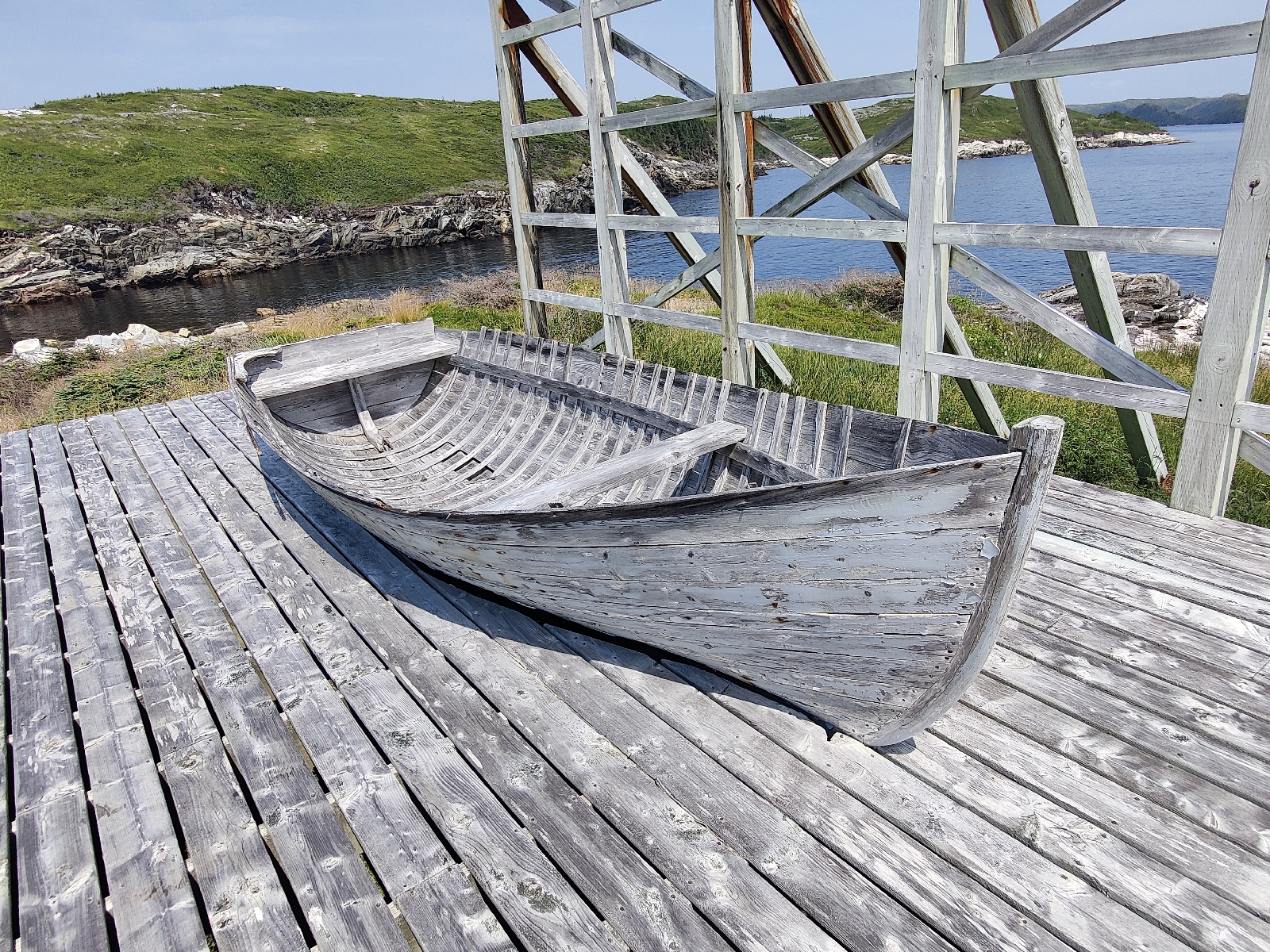
...and walked its length to the ramshackled boat house at its base which the CCA Guide made a point of saying was private.


It didn't look like it had been used for years however and was in a very derelict state. I was puzzled by its position given the apparent lack of access from landwards but then discovered a very overgrown track covered in gorgeous wild flowers behind it, that wound its way up the wooded hill.


I followed it upwards for twenty minutes or so until it met another track that was clearly in use and which I summarised, must join with a proper road fairly close by. By the time I got back to the spit, many of the locals had left, but a gaggle of youngsters with two jet skis and a small speedboat had set up 'camp' on a small beach near Bonny and were having quite an exhuberant time. It spoilt the peace and quiet of 'my spot' but they had just as much right to be there as I did and thankfully, just as I had concluded that the gathering gloom meant they must be staying the night, they left. Even at jet ski speeds they'd be hard pushed to get back to Beddek before dark, I thought, and I hope they don't run out of fuel.

Back on Bonny hoisted the dinghy back on deck in preperation for departure the next day - Sunday. It would be the last short leg (about 25 miles) of the cruise with St Peter's being Bonny's last port until next year.

I got the anchor up around 10 a.m. the next morning and motored towards the lifting Barra Straight Bridge, a few miles down the Great Bras. It's a very slick, yacht friendly operation. One simply has to call the operator up on the vhf about half a mile out and he has the bridge lifted by the time one arrives. 

A yacht went through in the opposite direction just before I arrived and so I expected to have to wait around for a while, but no, despite having to close the bridge to road traffic twice within 10 minutes, that's exactly what happened. Something of a contrast to the Queensferry Railway bridge across the River Swale, back home. The last I heard, yachts could only go through when it opened for commercial river traffic. There's precious little of that around and so boats can end up waiting for hours to transit the bridge which makes planning a passage through the shallow tidal waters of the Swale, something of a lottery. It's not surprising that hardly anyone tries to do so anymore!

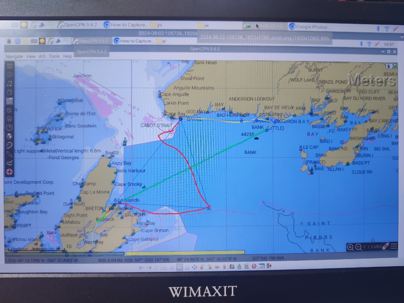
Anyway back to Great Bras. Once through the bridge I hoised full sail and we ghosted along slowly for a couple of hours. Eventually though the wind died completely and if I given I wanted to make St Peter's before dark, the engine went on. We motored on across the widest expanse of the lake for the next couple of hours until a fitful breeze on the nose enticed me to try sailing once more. Eventually, it settled down into a respectable breeze, still on the nose and now we had a maze of islands and narrow channels to work through. I decided to make the most of my last day on the water and committed myself to sailing the rest of the trip provided there was wind and sufficient daylight. We only had about 15 miles to go and although we'd probably have to sail getting on for double that distance, there was still 8 hours of daylight left, so we had a reasonable chance of making it under sail.


Some of the sailing did require some pretty close quarter tacking as can be seen from the picture above. We started sailing at the green marker near the two shallow patches marked in dark blue. 

The first 'squeeze' was the channel to the west of Doctor Island. I tacked into it a little too early and had to scrape across the shallows before the next tack. The next pinch point was the neck between Carters Point and Macleans Point which required a very short tack in order to get through. Next was the entrance to the passage south of Beaver Island. Fortunately the wind veered a little which allowed us to squeeze through hard on the wind but without having to tack. Finally, however, we ran out of wind and space at the Beaver Narrows. High ground on either side made the wind very fluky and the channel was only a couple of boat lengths wide and so reluctantly resorted to the engine to motor through the narrows and on to St Peter's less than a mile away, where at 6.30 p.m. I picked up a mooring in preperation for moving into the marina the following day. As I did so I heard a shout. It was Michael and Sabine on board Bleubeere moored in the marina. I had last seen them in Halifax! 

The next morning (Monday 5th August) I topped up with diesel at the fuel dock and then went into the Marina to get the boat ready to hauling out on the Wednesday. Before that though, I whiled away the morning over coffee and with Michael and Sabine aboard Bluebeere as we caught up with eachother's travels over the previous few weeks. They had also arranged the evening's social event - we were to be the guests of fellow OCC members, Bernd and Christine aboard their custom built, Van de Stadt designed, 50 foot Aluminium, Expedition boat "Infinity" moored just across the way from Bonny. After leaving Halifax (which is where they had entered Canada) they stopped off more frequently than Vince and me and initially sailed westwards to visit Liverpool, Shelburne and Lunenberg before resuming a more liesurely eastbound cruise along the Nova Scotia coast. They had as a consequence, arrived in St Peter's only a few days before me. 

Back on Bonny my priority was to prepare the mast for lift out. This would be the first time I had had the mast lifted since acquiring the boat and I wasn't looking forward to it. The mast is held in place by it's 'standing rigging' - a network of 9 steel cables, each of which is tensioned by a bottle screw at it's base and each of which is locked in position by pins which prevent it from unscrewing itself. My job, in advance of the lift, was to remove the sails and boom from the mast and then remove all the pins from the bottle screws so that the rigging could then be removed quickly once the mast was supported by the yard's mast crane. 

Removing and packing up the sails was the first job and a bit of a handfull and turned out to be a bit of a handfull on my own. Thankfully, Berned noticed the sails were getting the upper hand and came over to help even out the odds. By the time we'd got the sails packed away I'd had enough for the day.

Later on board Infinity, I overheard Bernd talking to Michael about a job that needed doing at the top of Infinity's (very tall) mast - the re-installation of a special camera. Perhaps a little foolishly, I volunteered for the job and so the next day saw me suspended at an alarming height from the top of Infinity's mast with a bucket, a few tools and a state of the art and very expensive camera. Fortunately, I didn't drop anything and was able to successfully install the camera. It performs much the same function as the camera/sensor systems on modern cars by providing the helmsman with a view of what would otherwise be significant blind spots as they pilot the boat through a crowded anchorage, narrow channel, or marina. Coupled with both a bow and stern thruster, makes manouvering the large boat in crowded waters, much less nerve wracking than it would otherwise be. A few days later I waved them off as they continued their cruise up the lake and it was quite surreal to watch 50 foot of boat move sideways off the fuel dock against an on-shore breeze!!

I was invited for a gorgeous fish dinner that evening as a thank you. Then after dinner I hot footed over to Bluebeere for drinks hosted by Michael and Sabine. Their other guests were their neighbours - a delightful couple who had just sailed down from the Great Lakes, via the Gulf of Saint Lawrence - and John van-Schalkwyk, OCC Port Officer for Halifax who, along with his lovely wife, Heather, had hosted such an enjoyable evening at their home in Jeddore Harbour some weeks previously.

The next day, Tuesday, I had to complete the preperations for removing the mast. Unlocking the bottle screws was straightforward enough. The next job though was to disconnect the various electrical and electronic cables that run through the boat and up the mast. These include the cables for: the various navigation lights, the vhf radio antenna, the (currently defunct) AIS antenna; and the radar. Some of the cables for the lights already had joins in them below decks and so they were easy to deal with. One, ran all the way back to the fuse box in one piece but cutting that was not an issue - it could easilly be re-joined like the others. The cable for the vhf was also in one run but after removing the jack connector that went into the radio, I was able to pull the cable through the internal truncking and then up through the deck gland. That left the multi stranded Radar cable. The end that plugs into the chartplotter display has a very bulky plug on it which I knew would be impossible to pull through the trunking and/or deck gland and the other end runs through a waterfproof gland on the radar dome and is connected inside the dome via multiple connectors. After inspecting the installation (half way up the mast) I concluded that the prospects for removing the dome cover, disconnecting the multiple connectors and extracting the cable through the waterproof gland without damaging or losing something, were not at all good. That left only one option. I would have to cut the cable below deck and re-join the various strands once the mast is re-stepped! It was the last bit that concerned me most. Radar connections are notoriously sensitive and must be of the highest quality in order for the screen to display a useable echo picture. After agonising for hours I finally cut the cable! 

Lifting the mast out was a little nerve wracking but the yard team clearly knew what they were doing and with the help of a few other boaters, the whole operation went smoothly and the mast was soon lying on four trestles alongside the dock and a number of willing hands helped me tidy up and secure the various bits of rigging to the mast in preperation for moving it onto the nearby storage wrack where it would remain for the duration of the lay-up. 


That evening Bonny was extracted from her natural habitat by a fearsome looking truck and trailer and moved to her new home at the back of the marina's boat storage area.

Over the next week or so I worked through a succession of jobs to prepare the boat for over wintering in below freezing temperatures. It's suprising how many systems and provisions contain water which either needs to be jetisoned or replaced with an anti-freeze mix....On my last morning I suddenly realised that I would need to donate my remaining stock of beer and soft drinks to the marina. What about the Gin and Rum - would that survive? I'll let you know next May!


Friday 2 August 2024

Fare ye well Newfoundland

The Isle aux Morts fades into the distance as Bonny heads south.

It was the 29th of July, the winds were still blowing from the south/south west; time to head back to the Bras D'Or Lake. 

After a couple of days on the island of death, there was a subtle, but all too significant change in the forecast; the wind would now blow from the south for the next 24-36 hours! Perfect (almost) - if we were still in Hare Bay - bang on the nose again from the Isle aux Morts! Still there was no point in complaining, no one would take any notice and anyway it wasn't as if we would have to battle through gales. The wind was due to revert to the south west after a day or so. 

Should I wait or go? A bird in the hand and all that. I decided to go. I'd sail close hauled on the starboard tack until the wind veered to the south west and then go about on to the port tack. With any luck by then we'd be far enough south to lay Sydney or the Great Bras D'Or. It would take us twice as long to cover half the distance we sailed on the way out, but so what, time wasn't that much of an issue - I'd deliberatley built a big cushion into my schedule and still had plenty of time to get to St Peter's for the lay-up and subsequent fly home on the 18th August.

As we left the Isle aux Morts and the rest of Newfoundland's south coast astern, I looked back in wonder at this remarkable land. A land, of which, I had seen only a fraction. A land which hosted one of humankind's worst acts of destruction on the natural world - the near total decimation of the North Atlantic Cod population - yet remains one of the wildest and most beautiful places on the planet. A land with the most treacherous coast imaginable, where a few generations of hardy folk eaked out a living and left as their legacy, some of the most friendly and helpful people I have ever had the pleasure to meet. I hoped very much that I would re-visit their wild atlantic shore one day.

Apart from the wind not listening to the forecast for the first six hours or so, when it blew steadfastly from the south (which made port tack rather than starboard, the more favourable one); things more or less went to plan. The forecast was for winds of 10 to 25 knots over the next couple of days. Normally I'd put a reef in before the wind got to 25 knots (especially with night approaching) because of the risk of the wind increasing further, but with Starlink, I could get almost real-time weather information from Windy. It didn't show any significant increase over 25 knots and so I carried full sail for the entire passage. From time to time things got quite exciting, but we never dragged our lee rail under (which is a good hint that a reef is required). 

The Hydrovane came into its own. I just had to set the wind vane to the optimum angle at the start of each tack and forget about it in the sure knowledge that without any effort on my part, it would take advantage of every temporary change in wind angle and steer Bonny on the optimum course.

It was though, something of a curate's egg of a passge. Sometimes we ambled along at 2 knots, barely with steerage way, at others, we were charged along at 6-7 knots. For the most part we had clear blue skies during the day and starry nights; with the exception that is, of fog for about 6 hours on the first night. Once again, it was comforting to have the radar, although we 'saw' no other vessels until crossing the approaches to Sydney Harbour on our second morning.

The wind veered to the south around 1300 on the second day and so as planned, I tacked to the west. By then we had made sufficient progress south to have the sheets slightly eased whilst heading south of our destination. The wind was due to back to the south west once again that night and the last thing I wanted was to spend even more time beating to windward. A slight detour then, prevented that necessity later.

In the end I got it about right and it wasn't until the last few miles between Sydney and the Great Bras D'Or, that we had to get hard on the wind to lay the approach channel. Once reached, the wind would be dead ahead for the last 15 miles down the Great Bras, to Otter Island, the end of the passage, but I had already decided that I would motor that bit.

The final obstacle was the current in the Great Bras D'Or. Would we be fighting it or would it be with us? The tide would be ebbing and so logically it should be against us. In fact it ran with us through the narrows and then half way between there and the bridge, it ran in the opposite direction; then once through the bridge it ran with us again! Most peculiar. Thankfully, despite dire warnings about it's strength, the most I noticed was two knots and so it didn't really matter that much one way or the other. 

The anchor went down at Otter Island at 0930 on the last day of July. My all too brief excursion to Newfoundland was over. Would I make it back next year?

It had taken 44 hours to cover the straightline distance of 100 nautical miles between the Isle aux Morts and Otter Island, but we had actually sailed 211at an average speed of 4.65 knots. Measured in a straight line, we averaged less than 2.5 knots! I guess that's one reason why 'gentlemen don't sail to windward'!

Bonny's cruise to Newfoundland and back..

The green line is our outward track from Otter Island to Cape La Hune - 178 nautical miles/avg speed 3.4k

The yellow line is our track from Hare Bay to the Isle aux Morts - 83 nautical miles/avg speed 4.5k

The red line is our track from the Isle aux Morts to Otter Island - 211 nautical mile/avg speed 4.65k

Monday 29 July 2024

Isle aux Morts (Isle of the Dead)

It's a bit of a grissly name isn't it! There is of course a reason for that, but I'll come back to it later.

The Isle aux Morts lies very near the western-most extremity of New Foundland's south coast. I headed there on the first leg of my return journey to St Peter's on the Bras D'or Lake, Cape Breton. The hope was to get a better angle from the prevailing south westerly winds, for the passage across the Laurentian Channel seperating Cape Breton from New Foundland. It also meant I would get to experience a somewhat less dramatic, but as I was to discover, no less treacherous, coast. My discovery was historical rather than experiential, I hasten to add.

The 120 mile or so passage took 24 hours almost to the minute. The forecast was for mainly light headwinds and so I was fully resigned to motoring all the way. As it turned out though, I managed to sail on and off, for perhaps half of the time, which was a bonus. 

The first part of the night was the most tiresome, with no wind and thick fog. The noise of the engine made it difficult to hear the alarm from the radar monitor, which meant snatching even a few minutes 'sleep' every 15 minutes or so, all but impossible. In the event I encountered no other vessels overnight but it would have been nerve wracking in the extreme to have been in that fog without radar.

Things improved later with the arrival of a few hours of a sailing breeze and the lifting of the fog.

On arrival at Isle aux Morts, I moored alongside the town quay; around which there was a lot of activity. It turned out I had arrived in the middle of their "Harvey Festival", held every year at the end of July to celebrate the life and heriocs of one of the earliest settlers in the area. George Harvey arrived from Jersey in 1780 and subsequently, along with his daughter Jill and their dog, affected two major maritime rescues of the crews and passengers of  sailing ships wrecked on this treacherous coast. 

A very friendly local helped me moor up.

My guide book said their were two shops in Isle aux Morts but they had both closed down!

I was therefore extremely grateful when Rolly (the friendly local) later drove me into the nearest major town (Port aux Basque) about 10 miles further west, to get some cash, do a bit of shopping and fill my reserve diesel jugs. 

That night I went along to the open air music event held as part of the festival and met up with Rolly (and his wife) once again. I was hoping the music would be local folk but it was loud rock. The band was actually pretty good, but these days I find it almost impossible to converse amongst such a din. I spent a couple of hours there and went back to the boat for midnight. I was pretty knackered anyway, having got little sleep the previous night.

The next morning (Sunday 28/7), before the wind got up, I moved the boat off the quay to a nearby anchorage with the delightful name of "Mickle Tickle" - a narrow stretch of water between "Mickle Island" and the mainland.

After a late breakfast I rowed ashore to walk the "Harvey Trail", established by the locals to remember and celebrate the life of the Harvey family.

The trail started somewhere at the other end of the town which, back in the hay day of the Cod Fisheries, was a major settlement boasting a large fishing fleet and fish processing plant and thousands of residents. Today, the fish processing plant is a crumbling ruin and only a few hundred people live here permanently and all the shops have closed.

I had a little difficulty finding the start of the trail, but once again Rolly came to my rescue. Driving past, he stopped and took me to the trail head. A friendly and most helpful chap.

Before beginning the trail I took a look around the cemetery just next to the start.

I wondered whether there were any "Bagg's" or "Baggs'" there. Sure enough, there was one..

Maybe one day, I'll try and find out more about them.

The trail wound it's way along the coast...

...but every so often, sections of the land it was on, had fallen into the sea...

...victims of the remnants of Hurricane Fiona that ravaged this coast in 2022!

Later on the trail I stopped and chatted to a local who was repairing it.

The gentle, but wild landscape seemed to be peatbog over a granite substrate (which often pretrudes through) peppered with water Lilly ponds...

... and is prefuse with wild flowers....


The trail begins with a convenience....

... and  has half a dozen signs erected along its route telling the story of the Harvey family's exploits (it's well worth reading their account in full)....

As you can see, some of the signs have fallen victim to the storms that have continued to lash this coast (the most recent being Hurricane Fiona in 2022).

I hadn't fully appreciated that this far north was subject to Hurricane damage, but it clearly is. Fortunately, there is no such weather around at present and St Peter's in Cape Breton, where I will leave the boat is off their normal track

At the end of the trail is a replica of the punt (I have my doubts as to it's accuracey however - it seems much too fragile to have served the purpose described) - the open boat that the Harvey's used on their rescue missions....
I depart for Cape Breton this afternoon.  South Westerlies are forecast for the next 24 hours and should then back to the south. I'll therefore sail as close to south as I can make until the wind veers and then head west. Whether that will take me towards the north east or the south end of Cape Breton, is too early to be sure, but if it's the south, I would probably continue on to the St Peter's canal without stopping, which may make it a two day trip.

Friday 26 July 2024

Hare Bay arrival, exploration and departure

24/7/24

As forecast it is another beautiful day, but with no wind and so we motor the 12 or so miles to the entrance of Hare Bay, which, just like La Hune Bay, is no mere bay, but a fully sculptured fiord.

Somewhat suprisingly as we pass into the fiord, a breeze does spring up from the south and we are able to sail the 6 or so miles up to our destination, Sandy Point, at the head of the fiord.

Once again the scenery is dramatic.  Sheer walls of granite with significant greenery clinging to it rise vertically from the depths on either side of us. I guess the fiord is about 800 metres wide.

As I look back to the entrance, the door seems to slam shut.

My sailing guide describes the anchorage at Sandy Point, as the best on Newfoundland's south coast. In my view, a good anchorage must first and foremost provide shelter, then a straightforward entrance, a grand view, and access to an interesting shore.

Sandy Point is beaten on the last of these, by its fairly close by neighbour, the head of the "Morgan Arm" some 3 miles away. It possesses a rather stunning waterfall cascading down into a pool. It is, according to my guide, possible to anchor in the pool but there are dire warnings of boats "bouncing of rocks" that get it wrong and so I do not intend to risk it. I will though stop off for a look and if it measures ip to its billing, take the dinghy in from Sandy Point tomorrow.

I motor up to the entrance of "the pool" ..

....and am convinced I should come back to explore by dinghy. Then, on to Sandy Point. It's a spit that has developed across the other arm at the head of the fiord and behind it is perfect shelter from the slight chop that otherwise permeates the fiord. 

I'm out of fresh meat and so make a corned beef hash.

The view is pretty good...

Looking north

and looking south.

The closest access to the shore is the otherside of Sandy Point, which is the tree lined spit on the left of the photo above. The "Morgan Arm" is 3 miles further on. 

When I arrive at Sandy Point another boat is there which seems to be deserted. I can see no dinghy in the water or on deck and so I assume the crew are out exploring. I drop anchor a respectful distance away.

I am out of fresh meat and therefore make a half-hearted attempt to fish, with, unsurprisingly, no luck. Dinner is therefore a sort of corned beef hash and will be tomorrow as well!

As night falls I get slightly concerned because there is still no sign of the crew of the other boat. No anchor light appears and I don't detect any sign of life. I start to imagine that the crew had fallen foul of bears or wolves whilst exploring ashore!

I am aware of no more than a gentle lapping of the water on the hull as I drift off to sleep. Such a contrast to the anchorage at Wild Cove.

25/7/24

I get up around 0800 and poke my head outside. To my surprise I see someone moving about on the other boat and realise they are upping an anchor. I wave, but get no response and soon the boat is disappearing around Sandy Point. I decide I have just 'met' my first anti-social Canadian!

I muddle around for the next couple of hours and eventually get the outboard motor on the dinghy and head off to the 'Morgan Arm' with a decent packed lunch. Three miles there and the same back is too far to row and so I disturb the solitude. It's a relief to get there and turn the machine off.

I enter the pool and tie the dinghy to a tree.

The tree is out od shot to the left.

Then I clamber up the side of the fall...

....and look back....

There are enticing pools in which I decide to swim on my way back...

I continue on and walk up the river bed. I guess that rainfall has been fairly light of late because it's fairly dry...

I continue for what I guess is a mile whilst looking for potential trails I could take up the hillside. After a quarter of a mile there's a fork in the river bed. I take the left one. The two channels rejoin later and I return down the other channel.

I see signs of Elk or Mouse 

but not the living creature itself. However, creatures in great abundance are dragonfly. Of course they are too swift for me to capture on camera!

I turn back around at about 1 pm with my thoughts turning to my swim in the pools, followed by lunch!

I'm back at the falls by 2pm and locate the pool I had noticed earlier. I climb down the rocks to a convenient ledge by the water and don my swimming truncks. The likelihood of being 'surprised' by others here, is remote, but ever since Gary and I were caught with our pants down (or rather off) in Bermuda, I have adopted a more cautious approach to wild swimming!

The swimming is delightful - the water not exactly warm but no where near as cold as I expected.

After my swim I dry off on the warm rocks surrounding the pool, have lunch and then a very pleasant siesta. The temperature is just right to soak up the sun without burning and the large rocks make a surprisingly comfortable bed.

After my snooze I gaze around and cannot imagine a more delightful spot for a swim - I feel I am in the company of 'the gods'.

The horizontal slabs of rock on the right partially in the shade, furthest from the camera and against the natural wall, are where I entered the pool, had lunch and my afternoon knap!

Then I go back down the fall to retrieve the dinghy and head back to the boat. I notice another yacht heading up the fiord - it heads for the falls; I'm pretty sure they'll head for Sandy Point later.

I toy with the idea of exploring the beach on the east side of Sandy Point but don't. It's 4pm when I get back to the boat, just enough time for afternoon tea and cake before G&T's in the warm evening sun!

Later, the other boat anchors nearby and I go over to say hello. They're Americans but know this coast well. They're surprised to find anyone else here - the first time apparently! 

Back on Bonny, dinner is yesterday's leftovers of corn beef hash.

26/7/24

My plan was to explore further up the river by dinghy today, but it starts raining after breakfast. I check the weather for the next few days. Apart from the next 24 hours when the winds will be light and variable in direction, fresh south westerlies are forecast for the next week. Reluctantly, I decide I had better head west today and keep going to get as far west as possible so that when the fresh south westerlies arrive I'll have a slightly better angle on the wind for my return to Cape Breton. It will mean motoring for probably 24 hours. Hopefully, I'll be able to put into a convenient port near the west end of the south coast tomorrow evening and rest up before tackling the crossing back to Cape Breton.

It takes me a couple of hours to get ready to leave, including getting the dinghy up on deck. I'm not expecting heavy weather of course, but nevertheless I don't want to tow it overnight just in case.

I get the anchor up at 1.15 pm and motor around Sandy Point and down the fiord towards the open sea.