21/7/24

[Painting of Cape La Hune village found hanging in the last house standing.]
My sailing guide to Newfoundland refers to an abandoned settlement at Cape La Hune opposite the anchorage at Deadman's Cove and so after my hike up to the mountain yesterday, I decide I will go and have a look. It's a mile and half across the fiord and it's a foggy day with the visibility just good enough to see the beach on the other side where I assume will be the best place to land. I decide to row despite the distance. The exercise will do me good and once again it seems a shame to shatter the peace and quite of such a lovely place with a noisy outboard motor. Oh and it has also developed a small fuel leak which I have still not got round to addressing.
So I head across the bay around 1100 and on the way say good bye to David and Ingar aboard Nashwana, who will shortly be heading to Francois a few miles east along the coast. I'll probably see them there in a couple of days because I will also head that way tomorrow.
I anchor the dinghy off the steep shingle beach and take a line ashore so that I can retrieve it later, hopefully without getting my feet wet.

I then head across the beach that seperates La Hune Bay (the fiord we are in) from what is described as 'La Hune Harbour' on the chart, but once again its purely a natural indentation in the coast and fully exposed to the prevailing south westerly winds.

I subsquently realise that it probably did once serve as a harbour, but as I walk up the beach 'the harbour' slowly reveals itself, it seems a pretty unattractive one, with the ocean swell rolling in and bouncing off the cliffs and beach that surround it on three sides.
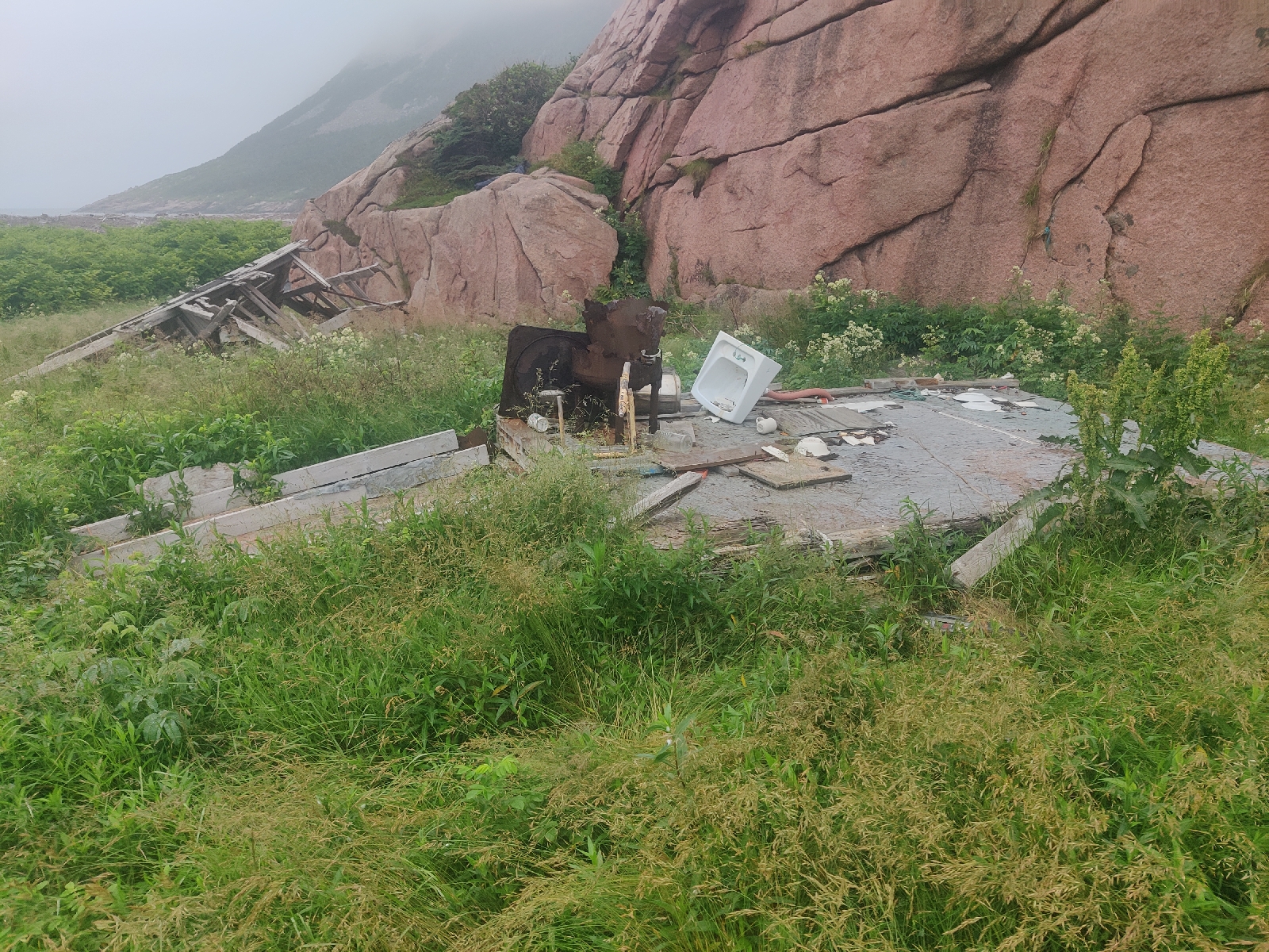
Once on the ridge of the beach, I notice what seems to be lots of mainly wooden debris scattered about on the other side and what I assume is a salt water lagoon between the beach on which I stand and the harbour on the other side.

I see nothing that looks like a desterted town. Slightly disaapointed I notice a large outcrop of rock forming a significant hill to my right to which I walk towards and start to make by way around. I come across the ruins of two wooden buildings complete with a porcelin sink and the remains of a battered stove.

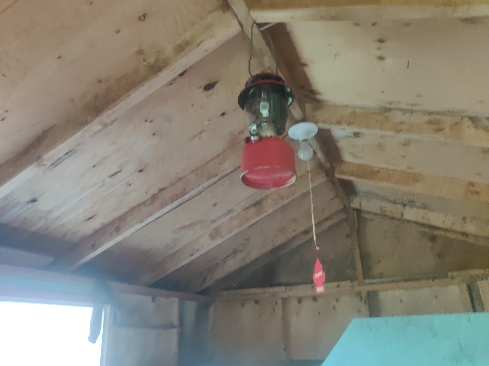
There's undergrowth underfoot and I realise it's very wet and so I return to the beach where I left my bag and don my not so waterproof over trousers and then return and continue to make my way around the outcrop. Within a couple of minutes my feet and legs are neverless sodden. Then, to my surpise I find an intact 'house', although it's not really much more than a shed.

The door is no more and I go inside. It's immediately clear that it's uninhabited but there are sign's that it has been used in the not to distant past. A generator sits on the floor and an electric lightbulb hangs from the ceiling along with a tilley lamp (which I have a strong urge to 'rescue' but I resist).

Next to the generator is a round table with a first aid box atop of it. I start to think it must have been used as a shelter by local fishermen.
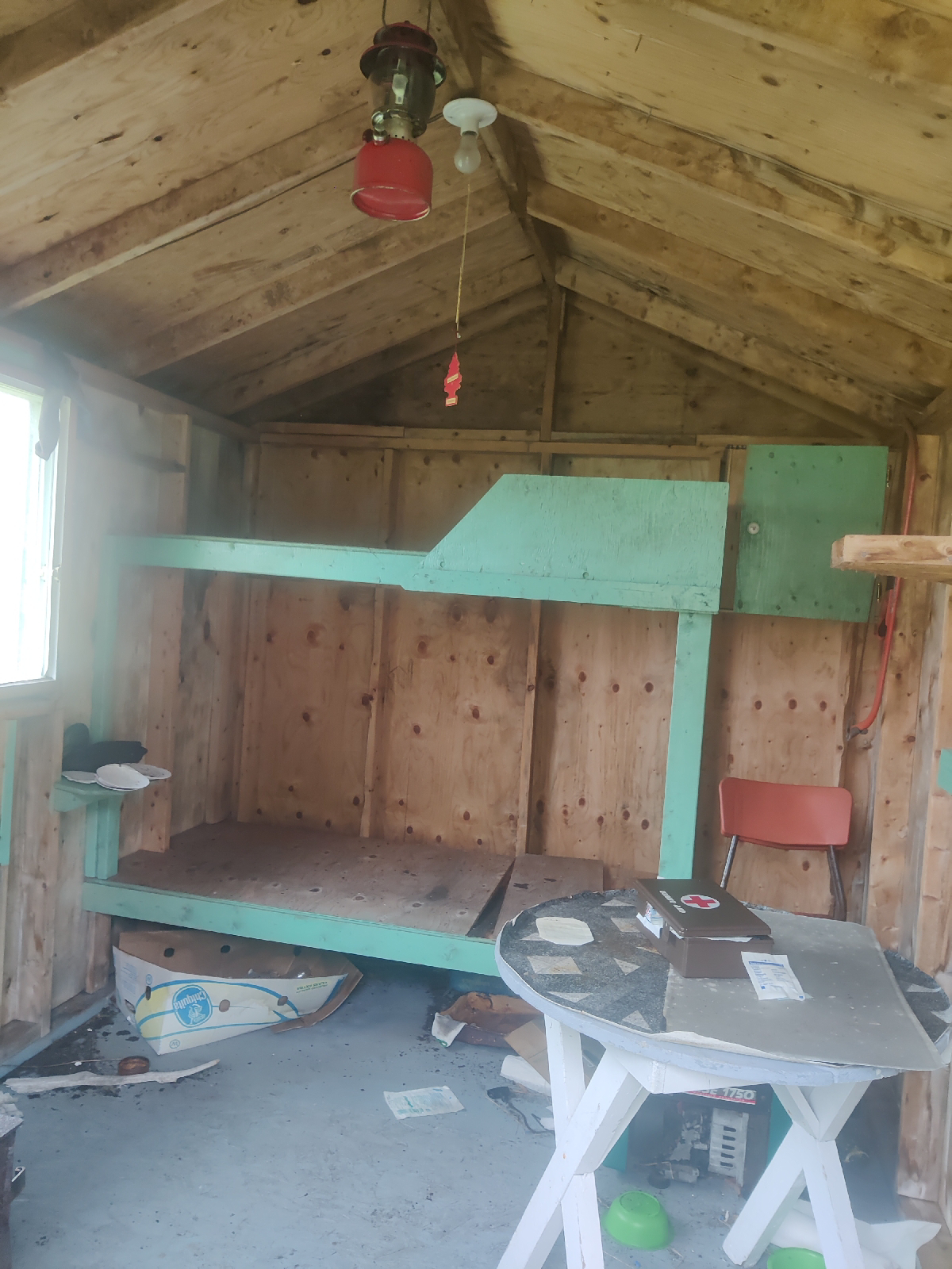
Built in bunk beds line the rear wall and on top of a small bedside table sits what I assume, are a couple of sea shell ashtrays along with an ornemental duck.

I revise my assumptions about the nature of the 'house'. It was clearly more than just a utilitarian shelter. Then I turn to face the wall opposite the window and am completely taken aback by what I see - the painting. The painting is clearly a view of the village in the days when it was still a thriving community. This house and the village clearly meant a great deal to someone. Was the painter - 'A. Dominie' also the occupant? The painting is signed and dated although frustratingly the painter hasn't included the century in the date - it's just ",88". Is it 1988 or 1888?
Later research reveals that Cape la Hune was settled by West Country English families in the early 19th Century, so it's possible it may be 1888. I search for clues in the painting itself but can find none. There are no vessels in 'the harbour' and no man made objects other than the buildings and the square fenced area which I think could quite easilly fit with either period. On reflection, I think the lack of vessels in the harbour, is a clue in itself. If there were vessels there when the painting was made, the painter would surely have included them. The fact that there are none suggests it's 1988 not 1888. I imagine the painter was trying to capture a by-gone era which meant a great deal to him/her, or to the person who commissioned the painting.
I stand there trying to take it all in - this thread of human existence hanging on an abandoned wall. Surely when the owner last left the house they must have intended to return otherwise the painting would have been taken. The impression I get though, was that it had been some years since the occupier was last here.
Further exploration confirms that the earliest the house must have been last used was as recently as the the 1980s. One cupboard has jars containing modern tea-bags and of course there was the generator on the floor. I should have examined it more closely but it can't be any earlier than the late 20th Century. That fits with the date of the painting being 1988!
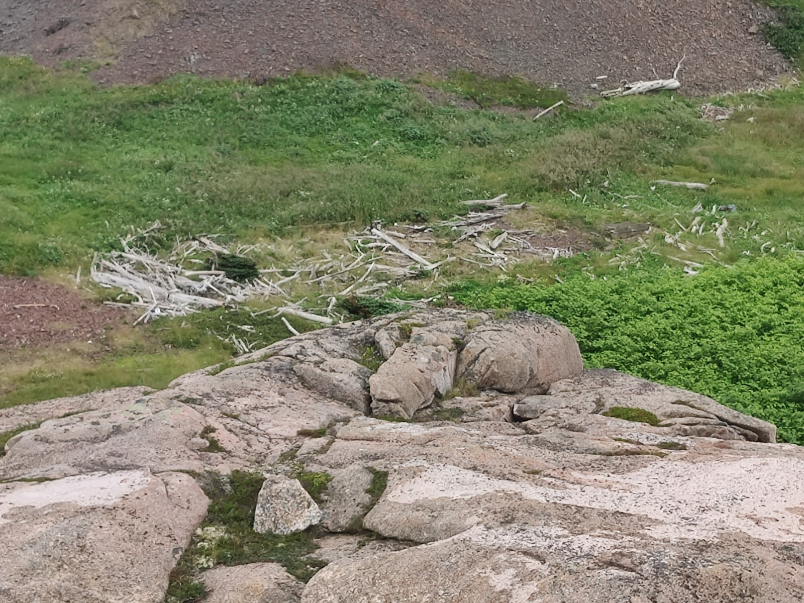
After further study of the painting I realised I can use it to better understand what was still to be seen of the village. Back ouside, I realised that what I had first taken to be random debris was no such thing, but were the foundations and other remains of the old wooden buildings shown in the painting.

I walked along the other beach (the one shown on the left hand side of the painting and could now clearly make out rectangular foundations). The lagoon shown in the bottom foreground of the painting was still there but whether it served a particular purpose I was not sure.

I had landed on the beach at the back of the church - in the painting. In it, Deadman's Cove is opposite the church where the triangle of green ascends the cliffs. The Lagoon is in the foreground, bottom left and the 'harbour' is the blue area above it.
I return to the outcrop - in the painting it has dark grey shadows depicted - and am about to return to the beach on which I had landed, when I noticed a trail going over the outcrop. I climb to the top and look back and suddently realise that I can now identify the foundations of the church. They stand out as a rectangle but with a pointed end - the end where the church steeple is shown in the painting.
By the way, the blue house depicted in the painting near the church is where 'the house' I found stands. It's clearly not the same building, but perhaps it was erected there years later by the owner/painter and the painting hung as a sad reminder of what once was. Whether the buildings were actually still standing in 1988 or whether the painting was from memory I have not been able to ascertain.
The village of Cape La Hune was originally founded in the early 19th Century by West Country English families and for nearly a hundred years thrived along with the Grand Banks fisheries. Then - to over simplify - La Hune, along with hundreds of other small, isolated, but previously self sustaining fishing communities that had grew up along Newfoundland's coasts, gradually became less and less viable as 'civilisation' marched on and as the fisheries became less productive and eventually collapsed. La Hune, like most of the other fishing communities had no roads connecting it with the outside world. Even today, in 2024, the coastal town of Francois, where I am berthed (on Tuesday 23/7/24) is completely cut off from the rest of the country except by sea. It has 60 permanent residents, 4 children, and two teachers in the local school!
The changing times were the beginning of the end for La Hune. It and hundreds of other similar communities were abandoned from the mid 1950s onwards as part of a resettlement programme instigated by the Canadian Government in response to the changing economic, commercial and industrial factors.
Whilst at the top of the outcrop I thought I might as well explore a little further and so walked away from the ruined village.
Glancing down the hill to my right I thought I saw a gravestone and so made way down to investigate. Yes, it was and there others too. I took photograhs of those that I could see.


One family name stood out, "Bagg", but there were others too. I have since found out that there are at least 150 graves in the now very overgrown cemetary - marking the last resting places of people who died between 1904 and 1960!
It therefore looks like Cape La Hune was probably an early casualty of the changing times. The Cod fisheries were not closed until 1992, but it is not hard to imagine that the hard working folk of Cape La Hune found the 'temptations' of the modern 1960s world too much to resist. Their contempories in urban or even rural mainland Canada would have been enjoying central heating, hot water, plumbing, electricity and the beatles, while they were still living in the 19th Century!
Subsequently I found that with the discovery of the Bagg family in the cemetry at La Hune, I had actually stumbled on its founding settlers.....
When Elizabeth Young was born in February 1876, in Cape la Hune, Newfoundland, her father, Charles Young, was 31 and her mother, Mary Elizabeth Miller, was 21. She married Hugh Bagg on 2 September 1897, in Hermitage, Newfoundland and Labrador, Canada. They were the parents of at least 3 sons and 7 daughters. She lived in Cape la Hune, Newfoundland, Canada for about 14 years She died on 12 July 1963, in Ramea, Newfoundland, Canada, at the age of 87, and was buried in Ramea, Newfoundland, Canada.
When Hugh Bagg was born in November 1871, in Cape la Hune, Newfoundland and Labrador, Canada, his father, James Bagg, was 37 and his mother, Mary Dollimount, was 36. He married Elizabeth Young on 2 September 1897, in Hermitage, Newfoundland and Labrador, Canada. They were the parents of at least 3 sons and 7 daughters. He lived in Cape la Hune, Newfoundland, Canada for about 14 years. He died on 2 June 1946, in Cape la Hune, Newfoundland and Labrador, Canada, at the age of 74, and was buried in Cape la Hune, Newfoundland and Labrador, Canada.
Sarah Jane (Bagg) Matthews passed away in Lower Burgeo on March 16, 1860.
Sarah and her husband "Old Uncle John Matthews" are mentioned in several histories of Burgeo, Newfoundland, as being among the very first settlers in the area. She was daughter of the founder of Cape La Hune who came originally from Burin or St Lawrence (Various internet sources, Including Ancestry.com)
When I got to to Francois, I found more Bagg(s) in the cemetry there.....


[Notice the addition of the "S" on the more recent graves. "Bagg" has become "Baggs"!]
Perhaps some of the family were still around? But no they weren't. My enquires revealed they have now all moved on. However, from the lady at the General Store, I did learn that the last Bagg(s) to live in Francois had a great fondness for La Hune.
Perhaps he is the owner of the painting in the last house standing in Cape La Hune!?


Quite an epistle!
ReplyDelete