
The friendly Harbour Master at Fort Baai (the white strip at the foot of the left hand mountain) suggested we would be more comfortable if we picked up a mooring around the corner at Ladder Baai ....

... and return to Fort Baai by dingy in the morning to check-in. For non-linguists like me, "Baai" is Dutch for "Bay"; Saba being a semi autonomous Dutch island. Quite what determines when a Dutch word is used as opposed towards English or French (both countries having previously governed the island) is a mystery. "Ladder" of course is English!
Ladder Baai takes its name from a daunting set of steps, carved in some places, that descend the near vertical cliff face that drops down onto the very narrow stretch of rocky beach. See the area to the left of the yacht in the photo below.

So we got up early and took the dinghy round to Fort Baai. It was a couple of miles around the coast but fortunately the sea was pretty calm and we came to no harm - we didn't even get splashed.
As we passed 'the ladder' I suggested we really should try the ascent before leaving the island. However when talking to the staff in the park office later, we were warned against attempting such a foolish venture. Apparently a number of yachties had recently had the same idea, only to have returned to find their dinghies had been washed away by a sudden increase in the swell lapping/pounding the beach! Of course, if I had been fully committed to the idea, I could have had Mick drop me off and pick me up. As things turned out, my enthusiasm never reached the heights required to follow up on such a fanciful notion.
Check-in was a painless affair aided by friendly staff, but in the process, I couldn't help notice the unusual number of white faces employed in these local jobs. This, it turned out, was an indication of the nature of the island. There was a white cop outside the Customs/Immigration office and a white immigration officer working inside. The Customs officer was black as was the Harbour Master whom I had to visit next (upstairs in the same building), but later in the Marine Reserve Park Office, where we had to pay a modest fee for our mooring and towards the upkeep of the reserve, we were met by 3 charming white women! In conversation with them, another hint of what we would experience, was let slip. The appropriately named town of "Windwardside" was, we were informed in encouraging terms, where most of the touristy places were.
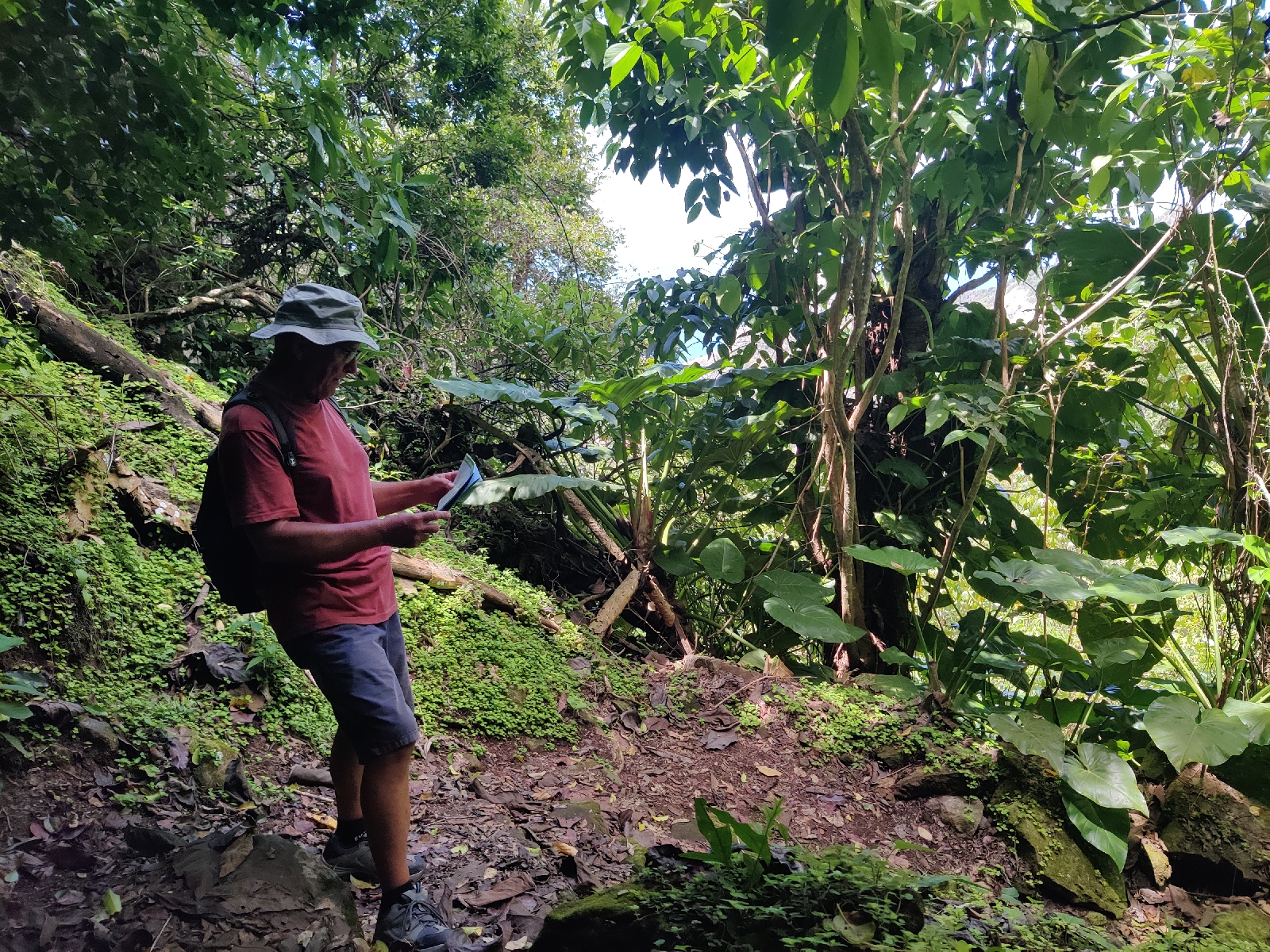
The hamlet and harbour of Fort Baai, is squeezed onto a narrow strip of relatively flat land at the base of an incredibly steep hill which rises UP to the first settlement of "The Bottom". Like "lambs to the slaughter" we thrust aside concerns about steepness and tourists and began our ascent to "The Bottom" on "The Road". "The Road" rises from Fort Baai and traverses much of the island, linking the port, first with "The Bottom" and then with "Windwardside". Apparently it took 20 years to build and construction began after the islanders had received expert advice from construction engineers warning them that the island's terrain was so inhospitable that it would be impossible to construct a road!
As we walked up "The Road" towards "The Bottom" it quickly became apparent that the construction engineers were quite right in their assessment - the road was quite impossibly steep. How vehicles manage to get up it, is anyone's guess and how they manage to get down without ending up in the harbour is an even greater mystery!
The ladies in the Marine Park Office told us it would take about 20 minutes to walk to The Bottom. Forty minutes after setting off we staggered into the first hostelry we came across - the "Busy Bee" and ordered breakfast of toasted sandwiches and Lime Juice squash. I topped mine up with a Latte and a pan de chocolate. An hour or so later, our wallets, lighter by some $40 US (the island's currency - another warning sign) we set off again to walk to Windwardside.
It was beginning to dawn on both of us that a) there was little prospect of us tackling the climb up to "The Bottom" a second time and b) we had wandered onto a very expensive island indeed. Given we were already so high up, the walk to "Windwardside" - a couple of miles off couldn't be too bad could it? So given we had got this far we may as well see some more of the island. A stroll through the rainforest hills would be just the thing. Mick had bought a good map for $5US at the Park Office, which showed a promising footpath to "Windwardside" from just outside "The Bottom".
Twenty minutes of more uphill walking later, we found the footpath and off we went into the forest. Before leaving the road we looked back over The (very neat and tidy) Bottom.

We hadn't noticed a single scruffy building on our way through and none were evident from our vantage point either. Most unlike anywhere we had been before in the Carribbean - even Martinique! Another clue!
According to our map, The Bottom and Windwardside lie at about the same altitude.
However, it was only after another 20 minutes of strenuous uphill walking through the rain forrest that we realised our footpath took us over a steep ridge that lay between the two settlements.

It was only the road that skirted around this ridge and was broadly level!
About a third of the way to Windwardside and still very definitely going up, we came across a wooden house by the side of the path. A white guy appeared, probably in his late 70s and waved us onwards. Nevertheless we stopped (any excuse) and chatted for a bit. He had a broad Irish accent and had apparently lived there all his life. If so he must have been descended from the original European settlers of the island which included a significant Irish contingent.
On we trekked. Another 20 minutes brought us to the top of the ridge. 10 minutes later still in the thick rainforest we heard what sounded like a leaf blower or lawnmower! In another 10 minutes we were outside a small boutique hotel lodge still surrounded by rainforest. We looked at each other - "cold beer"!?

The place looked deserted but clearly someone was there. We walked up the path and found the chap making a noise, Eddy from Colombia. He was looking after the place. It was closed today, but, yes of course we could have a beer. Saved!
After our break we continued on. Another 15 minutes and we were on the road, another 5 and we were in Windwardside. The appalling truth was laid out in all its awful glory. In the middle of this beautiful mountainous island we had stumbled into what to me seemed like a tasteless cross between a film set and a Disney village. "Twee" didn't come close. Suddenly there were tourists milling around gift shop after gift shop and restaurant after restaurant. Inexplicably, the island's main Dive centre was also here. We had a quick look around - I really didn't think I could stomach more - and then repaired to the cheapest looking restaurant we could find for an early (1230) lunch. The cheapest thing on the menu was hotdog and fries for $12US, but no, they didn't have any. A bacon burger for me ($17 US + fries $3) and a chicken sandwich ($15) for Mick. Beer, at least, was more reasonable, 'only' $3-3.50 a small bottle. With tax, lunch came to $40.25US.
We walked back to The Bottom and I at least, was thoroughly disillusioned with the island. At first sight it promised so much. Neither of us could see any reason for making a further ascent up the hill from the harbour and so agreed we would leave the next day, perhaps after snorkeling. After a beer in one of the Bottom's bars we descended to the harbour and were just in time to check-out for the next day.


No comments:
Post a Comment