I said good bye to the crews of the other boats and headed east. Zen Again would follow me out a little later. Indeed after about three hours they eased past on their way to St Peter's, Cape Breton, which they intended to make in one leg.

Mike returned the favour with a photo of Bonny...

My planned destination on leaving, was Liscomb, about 35 miles to the east, but the wind - 'billed' as a moderate south westerly never lived up to expectations and after a few hours of sailing at 2-3 knots, my planned ETA there of around 1800 was looking more like 2200 and so I studied the Pilot (The Crusing Club of America's excellent Guide to Nova Scotia) for a nearer alternative.
The rather wonderfully named "Ecum Secum" was one, but even at 3 knots I would be able to cover more ground to the east and so chose Hapes Point in Marie Joseph Harbour just a little further on.
I dropped the anchor in the gathering mist at around 1900. It's another delightful piece of wilderness although I did notice a church spire peeking through the pine trees about a mile up the point from the anchorage in the 'notch' joining the two parts of the Point together.
I made a mince one pot curry for dinner and caught up on the UK election results before retiring to bed.
Saturday arrived, chilly with drizzle and plenty of fog and so lay in bed until around 1000. I checked the forecast then which threatened rain all day and so given the possibility of spending the day confined to the boat I lit the heater and was soon warm and cozy.
On poking my nose outside after a very late breakfast, the rain had stopped and so despite the fog I decided to launch the dinghy and go exploring. I left the heater on though having decided the luxury of returning to a warm boat was well worth the cost of the fuel and besides which, not needing to re-light it on my return, would preserve my dwindling stock of meths.
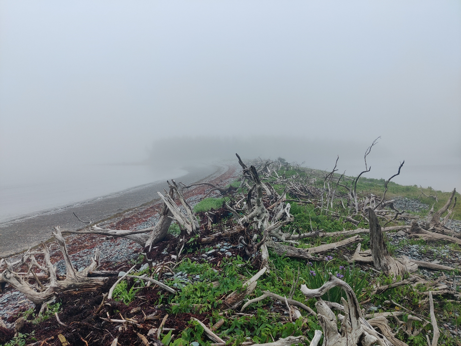
Ashore, I found a similar landscape and environment to Shelter Cove, but with some interesting differences too.

I landed near 'the notch' between the two parts of 'the point'. They appeared to be joined by a miniature and rocky version of Chesil Beach that joins Portland Bill to the mainland in Dorset in the UK.
On the east side of the notch where I had landed, a causeway/dam had been constructed (a long time ago).
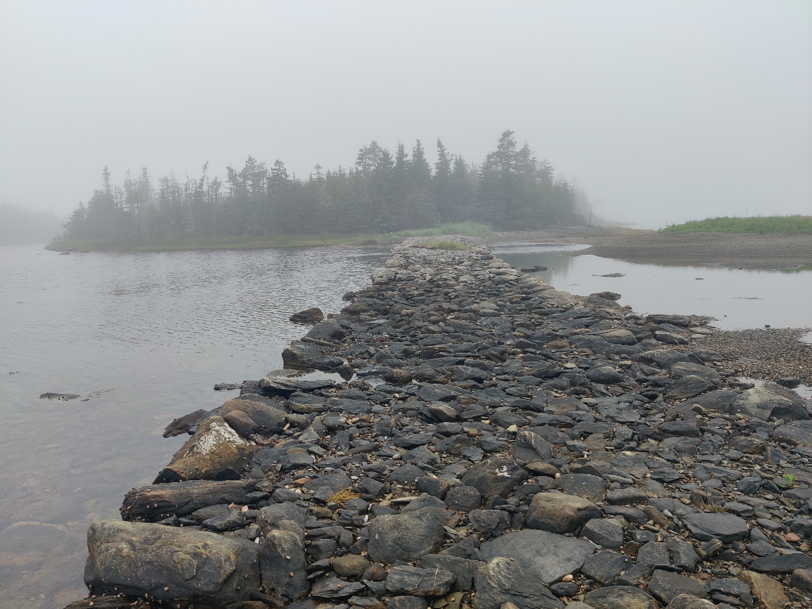
It had a gap in it, whether it was intended or not I could tell, but the causeway had the effect of creating a saltwater pond that filled and emptied with the rise and fall of the tide.
As far as I could make out there was no sort of settlement on the 'island' section of the point and so the purpose of the causeway was a bit of a puzzle, especially as both ends of it terminated up agsinst dense woodland, which as in Shelter Cove comprised a mixture of dead, dying and seemingly healthy (mostly) fir trees.
There wasn't much wildlife around apart from some gulls and a few pairs of elegant diving birds. They moved so swiftly that it was difficult to identify specific features, other than they were mostly white with a narrow pointed bill and a forked tail. I'll have to consult my book of oceanic birds but it's not easy to use. I wish someone would write one that lists and describes the birds that one is likely to come across by region. Perhaps someone has, but I've not found it. Actually a quick search on the internet suggests it may have been an Arctic Tern, I just don't remember noticing a black head.

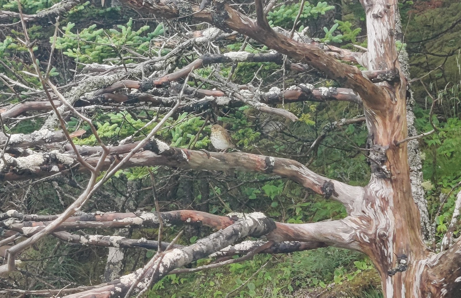
I also managed to capture a shot of what looked to me like a large plump sparrow. Yet again I'm not sure of its identification - the same source suggests perhaps a 'Fox Sparrow' but that should be much redder!
The coast here is clearly being eroded to a significant degree....

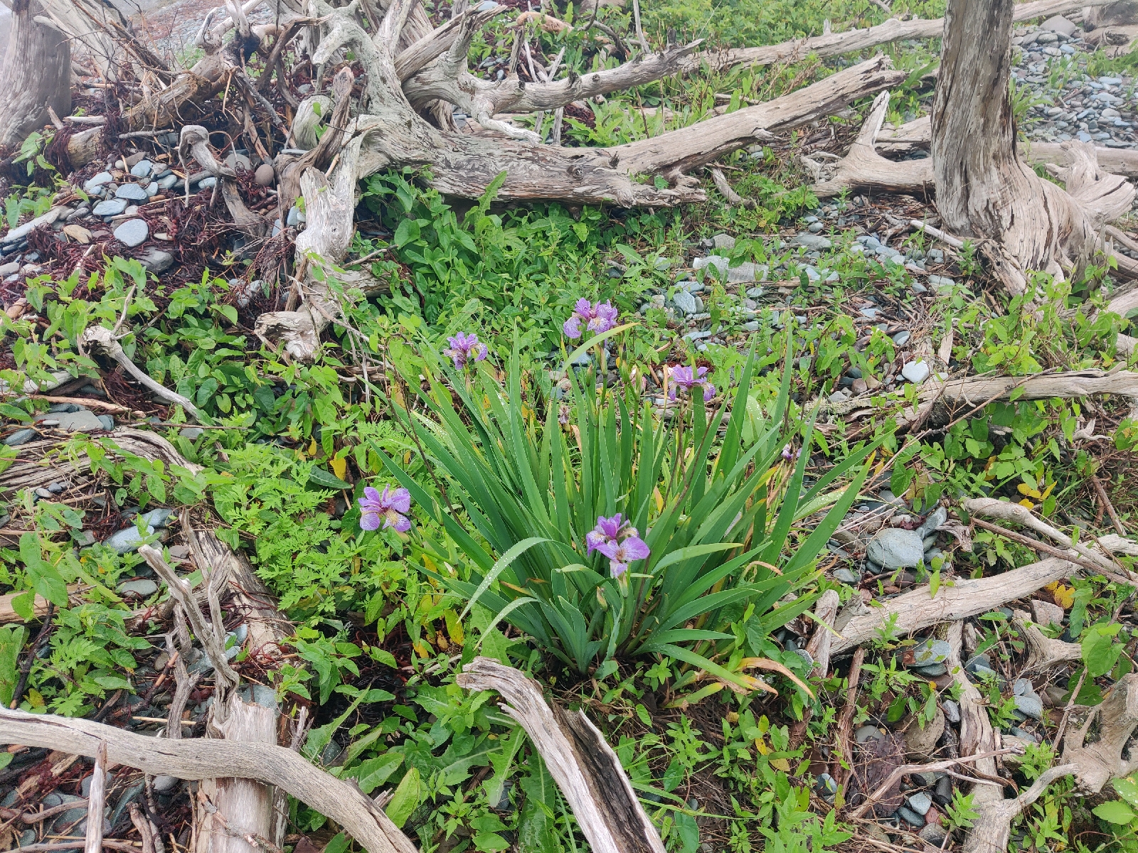
However, it's impressive that even in such a harsh salty environment wild flowers seem to be doing very well...


I left around midday on Sunday bound for Sherbrooke village near the head of the St Mary River about 20 miles to the east. The forecast was for early morning fog to clear by 0900 but come midday, departure time in order to arrive at the mouth of the river at low tide, fairly thick fog persisted. So I was to have my first experience of sailing in the Nova Scotia fog. The first few miles of the route went through a fairly rocky area and so whilst I was a bit anxious it would also provide useful experience of using the radar.
So I weighed anchor (a combination of by hand and the windless by operating the cut-off switch by the chart table) just after midday and headed east through the rocks, paying close attention to the chart plotter and the radar. After a while I was able to reconcile the radar images with the chart plotter. I didn't really need the radar for navigation, but it was good to become more familiar with it. I was certainly very glad I had the chart plotter because some of the rocks didn't appear out of the fog until we were almost on top of them!
Despite the fog we had a good sailing breeze (as is often the case in these parts) and made good progress. Indeed it wasn't long before I realised we were going rather faster than I had planned for and would arrive off the river while the ebb was still running. I tried to slow down by rolling in most of the genoa and by spilling the wind from the mainsail but Bonny took little notice - she probably slowed from 5.5 to 4.5 knots!
At about the half way mark I spotted what looked like 'a target' on the radar. A small echo picture where there wasn't supposed to be a rock. The radar has the facility to 'lock on' to the target and track it and provide information about it such as bearing, course and speed (if it's moving) and sure enough it was a vessel underway and not transmitting an AIS signal. This is where radar is so invaluable. You have to be more alert to potential targets, because unlike AIS, which only shows active transmissions, radar shows a lot more including rocks and vessels that aren't transmitting anything, but it means you can identify potential collisions even when you can't see the other vessel by eye or on AIS.
For a few minutes this one looked like it may be a problem, but thankfully it changed course and left us in peace.
We arrived off the river mouth in what was by then, bright and hot sunshine, at what I thought was an hour before low water and so 'hove to' for an hour before heading up the river. I was surprised to see that even then there was what appeared to be quite an ebb tide still running. Perhaps it was because the virtual tide gauge I was using was at the head of the navigable river!? Anyway I figured it couldn't be long before the flood was making and so carried on. Very soon the wind died and we had to continue under engine. About half way up the 9 mile stretch we ran aground despite being in a charted minimum depth of 2 metres. Also, strangely the tide still seemed to be ebbing. Of course, grounding on mud is second nature for a Medway sailor and provided the perfect excuse for a cup of tea!
After about an hour we lifted off the mud and continued on our way up the narrow wooded river. I spotted an otter swimming down river which was very pleasing.
I dropped the hook off the dinghy dock..

... just down river from historic Sherbrooke village in anticipation of an interesting outing the following day (the old village is essentially a museum comprising 18/19th Century 'working' trades and shops such as a blacksmith, pottery, post office, Taylors etc).
It was a bit strange to be totally surrounded by trees and marshland but of course we were 9 miles up the river.
I got ashore at about 1100 and walked to the village. Sure enough there were lots of old traditional buildings similar to those in Shelburne and Lunenberg, but everything was deserted - not a soul in sight, everything was locked up!


After wandering around and admiring the seemingly completely empty buildings, I walked on towards the present day Sherbrooke where I needed to do some shopping. I hoped I'd be able to visit the Whale Museum on the way, but that was closed too.
I went into the village fuel station/shop/cafe and had a coffee and muffin. There I learnt that the old village was closed on Mondays and Tuesdays!!!
Whilst drinking my coffee I overheard a couple of guys talking about fishing and the river and one asked the other if one could get a boat all the way up the river. "Oh yes, in fact a yacht's just come in yesterday". Que me. We got chatting for quite a while. As I went to leave one of them asked if he could come down and look at the boat. He used to sail years ago and was hoping to buy another boat soon.
So I climbed in his truck (of course) and we headed back to Bonny. On the way he explained that Old Sherbrooke is not entirely authentic; rather similar to Stonehenge, it's been partly re-constructed! I must admit I was surprised, at how perfect everything seemed to be.
The dinghy dock seems to be a favourite spot for the local youngsters - a group of them have been there all day swimming in the river's black - peat stained I think - water. It was surprisingly warm, but after the crystal clear waters of the Carribbean and Bermuda, I wasn't tempted!
Tomorrow I'll be heading back down the river and eastwards once more.


No comments:
Post a Comment